12/14/2009

Practice walk

Click on picture for enlargement

Helge and Sybille suggested a practice walk of 20km for coming weekend in John Forrest NP which is a very good idea. But there is no beach, it's an hours drive, you need a park pass to get in and it might be too hot in the bush, so I thought maybe it's an idea to meet in Bold Park and walk from there to City Beach, along the coast to Cottesloe and from there to the river, along the river to Claremont and via Karakattha back up to Bold Park. This makes a nice roundtrip of about 22-23 km. See map above.

What about if we meet Sunday morning (20 Dec) at 8am in Bold Park fully packed as we would do for the Cape to Cape walk?
At an average of 5km/hour with a few short breaks for a snack we should be finished around 1pm and can have a picnic lunch at Bold Park and go home after that for a nap in the hammock ;)

Let me know what you think about it or prefer to go to John Forrest NP, start earlier or later, etc.

Link to map of Bold Park (we follow Zamia trail)

I've added an alternative of 18km along the beach and river:

Sight seeing along the way

At Canal Rocks, in Leeuwin-Naturaliste National Park , the granitic rocks which jut out into the ocean are separated by a series of canals that have been hollowed out by the sea, we might, with a bit of luck, see humpback and southern right whales. And for sure we will spot some see dolphins along the track.

One of the loveliest spots to visit is the historic homestead at Ellensbrook, which is managed by the National Trust. A walktrail leads to a cave and the delightful Meekadarabee Falls, known to Aboriginal people as the "bathing place of the Moon", which is at its best in winter and spring.

In the right weather conditions there are some enjoyable and safe places to snorkel, such as at Prevelly and Gnarabup. Scattered along this coast are sheltered bays suitable for launching small boats, such as Kilcarnup, Cowaramup Bay and Prevelly. Tracks to the more isolated surfing and fishing spots on the coast are often suitable only for four-wheel-drive, because of the rough limestone that protrudes from the road surfaces.

Boranup Karri Forest, within the Leeuwin-Naturaliste National Park, lies between Caves Road and the coast, and creates a powerful contrast with the rest of the coastline. Tall pale-barked karri trees, reaching 60 metres or more high, dominate the hilly slopes and valleys. The Boranup Forest, as you see it today, is about 100 years old. It is a regrowth forest.

Good news

When and where are generators permitted?
Generators can generally be used at campsites in Western Australia’s national parks, conservation parks and State forests between 8am and 9pm.

But! Cape Leeuwin NP campings, under which Contos and Boranup, are GENERATOR FREE!!!!

I just called DEC to ask about fire bans and barbeques in Contos.
The lady told me there would be fire bans in summer but there are gas barbeques available on Contos which we can use.

I told her that last year we could make fires over Christmas in Boranup, then we had rain, so it depends on the weather probably. If it's hot and dry we are not allowed.
I was a bit worried how to cook on a small camping stove for ten people... As we don't have that big pots who even fit on the camping stove, so we have to use smaller pots and probably a few stoves. So if we can use the gas barbeques for meat and veggies and only need to cook pasta or rice on the stove that will be ideal.

12/11/2009

The people

From left to right:
Helge, Susann, Stijn, Sybille, Wilma, Nathalie, Sally.

Helen and Albert are still in The Netherlands but soon on their way down under. (photo made in Sweden)

We had a chat about the plans and this is a summary of it:

Thursday 24 December: Helge and Sybille are leaving Perth and going slowly down south.
Friday 25 December: Stijn and Wilma pick up Helen and Albert from the airport early in the morning.
After lunch we leave with two cars from our place: Stijn, Wilma, Helen, Albert in our car and Nathalie and Susann in Nathalies car.
We meet Helge and Sybille on Contos campsite. Fimo might also be there or he is at his parents place in Augusta.
Saturday 26 December: start walking; Helen, Albert, Helge, Sybille, Nathalie, Susann, Wilma. 20.5km from Dunsborough Light house to Wyadup Road where we get picked up by 2 cars (Stijn, not sure if it fits us all...)
Sally is arriving at Contos sometime today.
Sunday 27 December: Walk 26km from Wyadup road to North Point in Grace town. Fimo comes by today.
Monday 28 December: Walk 20km from Grace Town to Wallcliffe road
Nathalie leaves today.
Tuesday 29 December: Walk 18km from Wallcliffe road to Contos Campground, no pick up!
Wednesday 30 December: Walk 22.5km from campground to Hamelin jetty.
Thursday 31 December: Walk 26.5km from Hamelin Jetty to Cape Leeuwin Ligh house. BBQ at Fimo's family?
Susann leaves today and Sally is maybe joining her.
Friday 1 January: Everyone goes his/her way.

Camping gear: Everyone takes his own stuff and otherwise organises something with someone else. We will take chairs for Helen and Albert.
We also have the 40-liter fridge for milk and meat and a two point gas cooker.

Water: We are with four cars and every car takes enough water for drinking back-up. We take two 25 litre tanks if it fits in.

Food: Everyone takes care of their own breakfast and lunch and drinks. But we eat dinner together. Every 'couple' cooks one night for the group.

Suggestion for cooking: This is open for discussion!
25 Dec: sandwiches... ?
26 Dec: Stijn and Wilma
27 Dec: Susann and Nathalie
28 Dec: Helge and Sybille
29 Dec: Sally and Fimo(?)
30 Dec: Helen and Albert
31 Dec: CELEBRATION!

We also need to organise something for gas for the drop off and pick-up cars.

Suggestion for 6 days walk:

12/06/2009

Preparation meeting

When: Friday 11 December after work
Where: Cottesloe, north of the Indian teahouse on the grassy bit out of the wind.
What: Bring a nibble and a drink and we have a chat about our trip while watching the sun go down.
You might even want to bring your bathers for a dip in the ocean as they predict 32 degrees for Friday!
How: Be prepared on what you want to do and what not during the trip.

I’ll be there between 5.30 and 6pm so hope you can make it also before the sun sets.

11/27/2009

What to bring on the hike

What you definitely need to take hiking:
- Minimum of 2L water
- Sunscreen 30+
- Hat/cap with flap to protect neck or a scarf
- Sun glasses
- Fly net for those who hate the flys ;)
- Clothes in layers so you can peel of/on preferably light cotton
- Take something for all weather types, although it's summer it can be cold and rainy.
- Easy walking shoes (I am planning to walk bare feet on the beach parts)
- Towel and bathing suit for a swim to cool of during breaks
- Lunch pack/snacks
- Something to carry your stuff, either a backpack or on your hips (what I prefer)
- Medicine box (bandaids, aspirine, insect repellent, aftersun)
- I have a insect/snake bite extractor set which I will bring
- Compass
- Map of the route for that day
- Mobile phone if you have reach in the area (and GPS, Helge ;)
- Camera
- And a very good mood

Base camp at Contos?

The closeness of the forest to the coast has provided for one of the most well set up National Park campgrounds in Australia, at Conto Fields. Conto's is also one of the most beautiful beaches in the area, named by a local fisherman after a brand of wine which they used to drink in the 1950s. The fishermen built a shack on the isolated beach, which is now surrounded by vast quantities of empty bottles and flagons - testimony to many nights spent fortified against the cold by their favourite drop.
Conto's Beach and its surrounding bays are part of the Leeuwin-Naturaliste National Park and were originally part of a pastoral lease held by one of the founders of the area, A.P. Bussell. The lease changed hands a number of times - in the 1920s it was used as a pony stud. In the 1950s the paddock was cleared to graze cattle. The stock was walked a few kilometres around the cliff to be watered at a spring on the beach.

Each campsite in Conto's Field has a firepit, tabel setting, grass sites and shade.
The government purchased the land in the early 1970s and added the paddock to the Leeuwin-Naturaliste National Park. Near the entrance of the park is the magnificent Lake Cave - one of the original tourist caves in the area. The cave is home to some amazing formations that are suspended over large pools, which trickle through a maze of passages to emerge on Conto's Beach. This freshwater spring makes Conto's unique - it flows out onto the sand, icy cold and filtered clean by the limestone it passes through. A swim in the ocean and a quick splash in the spring is an invigorating way to start the day.

Until a few years ago the only access to the beach was either the 4WD track or a long walk around the cliff. The Department of Conservation and Land Management (CALM) put a major road through to Conto's and the bays further south. At the time the decision to put the road through caused quite a lot of controversy but the decision was prompted by a number of drownings in the area. Decent access was required if any rescues were necessary. CALM has since provided some excellent camping facilities just a few kilometres from the beach. Sites are cleared, secluded areas surrounded by bush and all have fireplaces and picnic tables. Some of the sites are perfect for a couple or family, while others cater for large groups. Jarrah millends are provided for fires and bush toilets are available.
Camping kitchen and even caravans and campers find their way in.

During the winter of 2000, CALM did major work on improving the sites and adding some new circuits and more campsites. there is now more than enough room to find a bit of privacy at all but the busiest of times. Campers can either stay at Conto Field camping area which has many comfortable spots, or at a few limited sites in the magnificent Boranup Karri Forest. Tracks pass through the forest and into low woodlands of peppermint, banksia and jarrah. The tracks emerge in coastal scrubland, which supports communities of animals including kangaroos and goannas, then continue onto the coastal bays and beaches. If you stay in the forest you will be overwhelmed by the local possums - a rare experience in WA.

Visitors to Conto's or Boranup should bring their own water or collect it from the spring on the beach, (it is a long walk back to the campsite with a heavy water container so don't overdo it). There is a rainwater tank at the main camping area and it usually has enough water but supplies are limited. Rangers collect a minimal camping fee and supplies can be obtained at Margaret River or Witchcliffe. You can also get great lunches and limited supplies from the cafe/kiosk at Lake Cave. Many of the Margaret River vineyards are close by and most of them serve an excellent lunch.

Camping fee: Per adult/per night $7
There are no showers, I originally thought they had, but we'll take the plastic shower bag :)
More info on DEC (Department of Environment and Conservation) website

A few of our videos while caming in the area


Leeuwin-Naturaliste National Park - History

The Leeuwin-Naturaliste National Park is located on the south-west coast of Western Australia, 261km from Perth. The park lies in the Aboriginal land of the Wardandi (people of Warden, the ocean spirit). The wardandi are one of the fourteen Nyungar tribes that live in the South-West.

Their land extends from the coast at Stratham to the sea at Augusta. The park stretches for 120km, from Bunker Bay in the north to Augusta in the south. Cape Naturaliste is the northern most point in the park. The first noted Europeans to have sighted the area were the Dutch, in 1622. They named the southwestern tip "t Landt van de Leeuwin" meaning the land of the lioness.

It was later explored by Matthew Flinders , in 1801, who renamed it Cape Leeuwin with respect to the Dutch who had first sighted the rocky headland.The area became a popular place for whalers and sealers to collect fresh water and to seek protection from the storms that whipped up off the southern ocean.
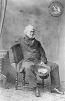
However the area was officially settled by Europeans in 1830 after the establishment of the Swan River Colony. New settlers who had arrived in Fremantle on the ship "Warrior" on 12th of March, 1830, were hoping to take up land near the Swan River Colony but, Lieutenant-Governor James Stirling, knowing that all of the fertile land had already been taken up, persuaded the settlers to move south, to an area near Cape Leeuwin.
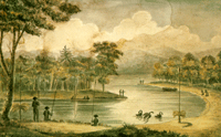
Captain Molloy, a small military detachment and about thirty settlers headed south and arrived in an area near the Blackwood River . Among the new settlers from the "Warrior" were Captain John Molloy and his wife Georgiana and John, Charles, Vernon & Alfred Bussell (who all became influential in the development of other areas in the south-west).

The site was named, Augusta, by James Stirling in May 1830, in honour of Princess Augusta Sophia, the second daughter of King George III and Queen Charlotte.

With very few of the settlers having a history or background in agriculture, it didn't take long before they discovered how hard life was on the harsh landscape.
Supplies from Perth came infrequent and small relief was found through the Whalers (predominantly American), who came ashore to collect fresh water and trade with the settlers. The settlers would exchange potatoes, meat and vegetables for much needed oil (for lighting), molasses and tobacco. However, even with the whaler trade, many settlers found the isolation and harshness of the area too much and they left Augusta including the Bussells and Malloys.
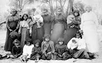
The settlers that stayed, used the local Aboringines to help clear the local hardwood timber and assist with crops and with the introduction of convicts to Western Australia in 1850, many convicts were given tickets-of-leave and sent to Augusta help the settlers cut timber (Jarrah & Karri ).
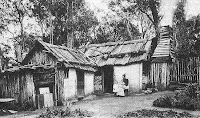
The banks of the Blackwood River were used to house convicts & guards and where timbers were pitsawn before they were loaded onto rafts and floated down to the mouth of the river (as Jarrah does not float).It would, however, be another twenty years before Augusta would flourish, due to the timber industry and a man named Maurice Coleman Davies. M.C. Davies established sawmills at Coodardup, Karridale, Boranup and Jarrahdene in the late 1870's and almost singlehandedly create a market and efficient industry for Karri and Jarrah hardwoods which was highlighted in the Paris Exhibition in 1878.
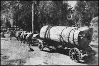
By the 1880's the timber industry was booming and mills, jetties, towns and a railway were built to cope with the demand for Western Australian hardwoods. Timber became Western Australia's second largest export, behind wool. By the early 1900's the demand for Karri and Jarrah from the area had declined and the last mill was closed in 1913.
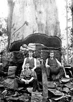
After the first World War many returned soldiers took up dairy farms in the area. Augusta is now a popular holiday resort, with among its attractions being the Cape Leeuwin Lighthouse and waterwheel, Jewel Cave, Boranup Forest and whale watching tours it also boasts pristine beaches, great fishing and friendly pelicans.

In 1957 the Leeuwin-Naturaliste National Park was established from crown land along the Leeuwin-Naturalist ridge and is managed by the Department of Conservation and Land Management.

Info from Margaret River Vista and google images.

10/06/2009

Cape to Cape guided tour

Join Environmental Encounters on this 8 day, small group expedition on the Cape to Cape Track in the Leeuwin-Naturaliste National Park.
More information here.